
I want to show the interested how the GPS satellites swirl over our heads.
Who posseses an handheld GPS receiver will know the page were the device shows the positions of the currently visible satellites. These constellations look more
or less static, but they aren't! Twice a day every satellite comletes a roundtrip.
By using a screenshot program, that is available
here, I made the effort to store the image of the satellite constellation every 5 minutes and made an animation out of
them.
The timelaps movie consists of 65 frames and spans nearly 6 hours in realtime.
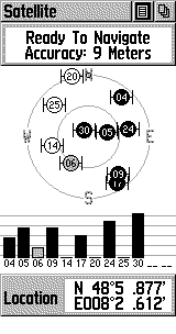
The outer circle is the horizon and the inner circle marks an inclination of 45°. With the GPS outside my roof window the line of sight was obstructed to the west.
The 45° angle of the roof is directly visible by fact, that the satellites
get black (active) exactly at the 45° inclination circle in the screenshot.
I removed some digits out of the location display, so that I don't have to fear
cruise missiles messing up TV evening. ;-)
Interestingly, there is a zone about 45° north, that is avoided by the satellites! Do polar scientists have besides chilly fingers also bad GPS reception?
And while I'm dealing with this anyway I made a diagram out of the displayed positions. For that I converted the displayed angles in north-south-direction with
/360°*40000km and in east-west-direction with /360°*40000km*cos(49°) into length values.
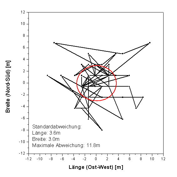
The calculated standard deviation is lower than the displayed estimated positioning error. Some displayed positions however are as far as 11m off from the average
position.
09/24/2003